

Up and at 'em! Time to go explore this peninsula.
After some bagels for breakfast at the Inverness Park Store, we head over to Bear Valley, a part of the Point Reyes National Seashore. Today, we're hiking the Earthquake Trail.
This trail, 3/4 of a mile...paved, no discernible elevation grade...takes you on an up-close and personal tour of the infamous San Andreas Fault with interpretive sign stations explaning everything you would want to know about earthquakes.

There's a way more popular (and not as accessible) trail nearby so the parking lot here is fairly empty and easy to find a space. A few handicapped spaces are at the trailhead, which is also where two accessible restrooms are. There are also several picnic tables here so you may want to bring a lunch with you. Of course, there are several nearby restaurants nearby that you can visit before or after too.
The trail pretty much forks as soon as you start. Take the left fork. It will loop back to this point before it's over.

There are a lot of trees, so this is mostly a shady walk. A gurgling creek is crossed by a wooden bridge.

At the far reaches of the trail, where this used to be a farm, an old fence goes off up the hill. This fence was here in 1906 when the fault snapped and caused the huge 7.8 San Francisco quake. The fence was split in two. One section sits 16 feet away from the other one at the fault line.

You can stand on the fault, straddle it, jump up and down on it if you want. Wheelchair users will have to watch about 10 feet away, though, because there are a half dozen stair steps up to it. The fault is marked by blue posts situated every few feet along the line.

Stay on the trail because there is a lot of poison oak here. Other than that, is a nice, easy, shady stroll through some oak forest and a few meadows.

Next, we're going to take a drive to the south end of the peninsula that is Point Reyes. Just past our hotel, we take the left turn going south. After a few bumpy miles on the main road, it's nice that this road has been freshly paved and is smooth for the rest of the way.
We drive for about 20 miles past beaches, historic cattle ranches, dairies, and a lot of open grassland.

At the end of the road, we reach the parking lot for the Point Reyes Lighthouse. The lighthouse, itself, and the visitor's center is closed on this Thursday but we can still walk out to it and enjoy the view.

If it was open, vehicles with handicapped plates or placards can drive up to the visitor's center and take advantage of the parking up there.

For us, it's a fairly simple half mile walk each way up the paved access road.

It is on a very high ridge and some of the looks down to the bottom of the cliffs can inspire a quick breath or two. It also is a great way to see the miles of empty beaches and unspoiled land stretching to the horizon.
At the end, where the visitor's center and restrooms are, there is a paved sidewalk taking you around the point to a paved platform where you can view the lighthouse and crashing waves far below.

When the visitor's center is open, able bodied people can descend the 300+ stairs to the lighthouse to get a close-up look. Otherwise, you'll just be able to get to this viewing platform...which also has an accessible picnic table if you didn't have lunch at the Earthquake Trail...but it's a grand place to take in some spectacular views of the northern California coastline.

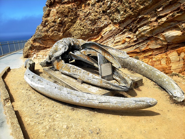
On the way back, we take a few moments to look at the gray whale skull that has been placed next to the trail.
We're going to go back to the van and continue on but we'll leave it here for now and pick up the rest of it in our next dispatch.
Darryl Musick
Copyright 2021 - All Rights Reserved
No comments:
Post a Comment