Monday, August 31, 2015

CALIFORNIA - Our Highway 395 Road Trip Moves Into the Cold Country

Follow Me on Pinterest1


Although the area seems relatively flat, the snow and trees give a clue. Just a few miles after leaving Mammoth, highway 395 hits the altimeter at 8,036 feet at Deadman Summit.
An exit leads to June Lake Loop, a back country of lakes, campgrounds, and the June Lake ski area, also owned and operated by the same folks back in Mammoth. We’ve yet to try it out but I’m told if you don’t like the crowds at Mammoth, June Lake makes a great alternative.


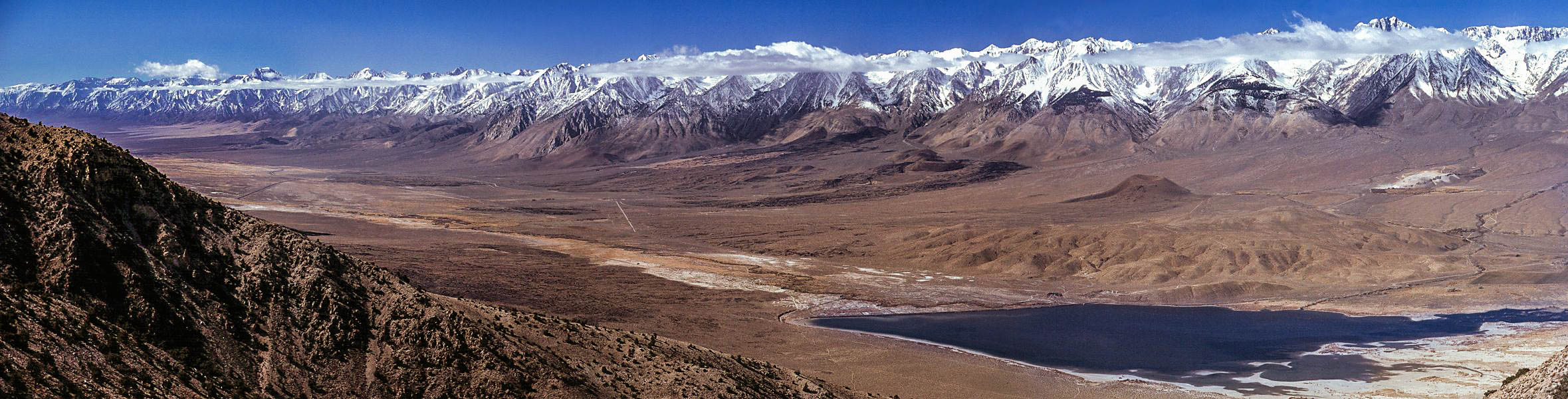
Coming down the other side of the summit a very large lake looms in the distance. This is Mono Lake, a brackish, fragile eco-system full of alien looking towers called tufa. 
As L.A. took all the water in this area, they also diverted the streams feeding the lake which has no outlet.  Mono Lake shrunk to the point where islands that supported nesting birds became peninsulas giving predators a bridge to the tasty birds.
Many court battles later, the streams are no longer being diverted and Mono Lake is making its comeback.


The tiny town of Lee Vining sits to the west of the lake, a nice rest stop along the highway.  Closer to the lake, fans of Clint Eastwood movies might recognize the area of the town he had painted red in High Plains Drifter.

At the south end of town, highway 120 begins its westward trek toward Yosemite National Park. Better known as Tioga Pass, this road is blocked by snow and rubble for much of the year. It’s only in the warmer summer season and into fall that you can actually drive that route.


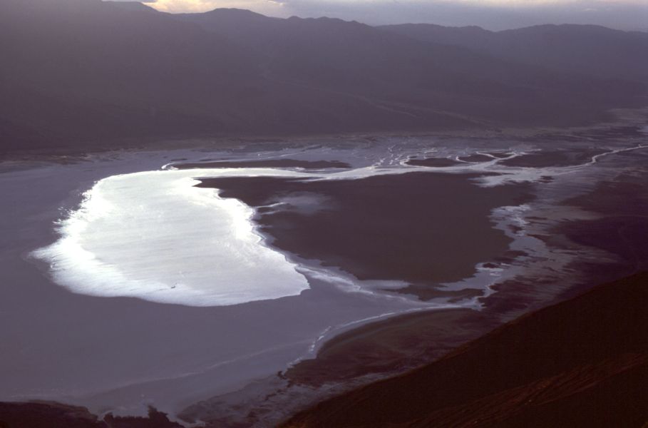
Just north of town, you can pull off to see the crazy tufa formations at the Mono Lake Tufa State Reserve.
Past Lee Vining, we’re climbing again. This time to the 8,138 foot height of Conway Summit, the highest elevation along 395.  Coming down from the summit, if you’re here in the peak of summer,you might want to take the detour to Bodie, one of the best preserved ghost towns in the country, a few miles to the east. Now, in the winter, the high country road is closed.

The next big town we come into is Bridgeport, a very pretty little high country town in a valley alongside the Bridgeport reservoir.  I’d been coming here for years…all in the winter…before I realized there was a lake here.  Mostly, I’ve seen the town under a deep blanket of snow where the gas prices will take your breath away.

It gets so cold up here that the Marines maintains their cold weather and mountain training facility to the west of town.  This is not the California of beaches and palm trees you see on the post cards.
Past Bridgeport, we become partners with the Walker River adjacent to the road.  The canyon narrows as we get closer to the state border, a lonely spot with the requisite small casino, Topaz Lake. The Best Western here actually looks like it’d be a great place for a get-away-from-it-all weekend.


After crossing into Nevada, we stop in Gardnerville to have dinner at the Overland Hotel. It’s a creaky old place with a bar and a dining room serving Basque fare.
Being seated, we are given a small carafe of wine, salad, soup, beans, and spaghetti before we’re even asked what we want for an entrĂ©e.  We get our steak and fish next, along with some great fries before having a little ice cream for dessert. All very good and filling.
Well fed, we head out back to our car where we join a short Frisbee toss with the kids living behind the hotel. It’s a short drive to our next overnight stop, Carson City, the capitol of the state where we’ll spend the night with owls, deer, and bullfrogs on an alfalfa farm.
-Darryl
Copyright 2012 – Darryl Musick
All Rights Reserved.

Pin It

Friday, August 28, 2015

SOUTHERN CALIFORNIA: Highway 395 Kicks it Into High Gear - The Northern Owens Valley


It's been 275 miles on the road, probably time to think about somewhere to lay our head. That would be the heart and soul of the Owens Valley, Bishop, California.


With a population of just under 4,000, Bishop is the big city of Owens Valley. It's here that you'll find the major services...stores, hospital, casino, fairgrounds, and lodging. You can get clean, comfortable rooms starting at around $60 at the peak season of summer, up to the $140 dollar rooms at the Best Western Creekside Inn, the prettiest and most expensive place in town.


It's your choice but we'll not spend too much here...Bishop is unpretentious and uncomplicated. We'll keep it simple and cheap.

In Bishop, travelers stock up for the trip ahead. Sporting good stores cater to fishermen and hunters who flock to the local lakes and forests. It's said that you can walk across Crowley Lake, just north of town, by stepping from boat to boat on opening day of trout season. Campers get groceries and road trippers top off the tanks and drain the bladders for the road ahead.


While many just stop for a minute and continue on, Bishop rewards those who linger a little longer.  


Schatz Bakery is the busiest place in town where you can get varieties of bread and baked goods that range from mediocre to delicious. Grab a lunch to go and cross the street to the pretty city park where you can picnic on the banks of the creek, watching ducklings trying to keep up with mom.


You can get cheap gas and gamble for awhile at the Indian casino at the north end of town.


As we leave Bishop on highway 395, we also say goodbye to the Owens Valley.  42 miles north, although it seems much closer, we come the next big attraction...and I mean BIG.


Local DWP hydrographer Dave McCoy set up a number of rope tows to facilitate his love of skiing in the winter. In 1942, he finally found a good, snowy spot and persuaded the forest service to give him a permit to open a ski area. Mammoth Mountain was born.


The name is apt, the mountain is huge and easily accommodates the thousands of skiers and snowboarders that crowd the town of Mammoth Lakes on winter weekends.


Snow can come down hard here...it's not uncommon to drive the streets of this town in winter with walls of snow ten feet high on either side.


Skiing ranges from the easy bunny slopes to the truly scary and expert slopes of the 11,000 foot cornice.


It's not cheap to ski here.  As of this writing, an adult full day lift ticket is $89.  Rooms average around $200 a night in season, although we once found a small basement room for around $90. The closer to the lifts, the more expensive they get...easily topping $500 a night for a room next to a lift.


For that price, you will get one of the world's great skiing experiences. Mammoth also operates an adaptive ski program run by Disabled Sports Eastern Sierra that runs around $150 for a full day of skiing and instruction, click on that link for more information.

Back on 395, heading north, we leave all traces of desert behind as we travel through the snowy Alpine forests of the Sierra, Mammoth, and June Lake.  Where we're going is not the sunny California that everybody is thinking of.


We'll be swinging through the Siberia of the west coast in the next leg of this trip.


-Darryl
Copyright 2012 - Darryl Musick
All Rights Reserved

Tuesday, August 25, 2015

RECIPES FOR A CHEAPSKATE: Lasagna


God has given us an abundance of tomatoes this year, the challenge is to use them all.

This week, it's everybody in the pool as I make a sauce for my lasagna. I have four hybrid, 1/2 heirloom, and about a dozen cherry tomatoes leftover from last week's harvest that I need to use before they go bad.


First step, chop them all up into cubes. The cherry tomatoes will just be cut in half like I did with my pizza sauce a few weeks ago.


As I dice, they all go into a bowl, awaiting their fate.  A tablespoon of olive oil in the bottom of a sauce pan is getting hot in the meantime, where I saute half an onion chopped up in a food processor.

Once the onions are translucent, the tomatoes join them along with half a cup of water, half a teaspoon of sugar, teaspoon of salt, a generous sprinkling of pepper, half a teaspoon of minced garlic, and another half teaspoon of oregano.


I bring to a boil, stirring, for ten minutes and then let simmer on low for a little over an hour.


When done, the sauce looks like this.


Next, I fry up a pound of Italian sausage and cook some lasagna noodles in boiling water for about eight minutes until slightly soft (al dente).


I oil up a baking pan with olive oil, lay in two strips of the lasagna noodles, and start to create layers. One layer may be sauce with sausage and parmesan cheese, the next sauce and ricotta cheese, the next sauce, cream, and mozzarella...it's up to you, whatever you want to put in.


Finished, I top with a generous layer of mozzarella to have a nice, melty layer of cheese on top.


375 degrees for 45 minutes, covered with foil. Remove the foil and cook for another 20 minutes. Take out and let cool for 10 minutes.

Serve and enjoy.

Darryl
Copyright 2015 - Darryl Musick
All Rights Reserved

Monday, August 24, 2015

SOUTHERN CALIFORNIA: Highway 395 Kicks it Into High Gear - The Historic and Beautiful Southern Owens Valley


Either you bring the water to L.A. or you bring L.A. to the water.” – Noah Cross (John Huston) in Chinatown (1974).

It helps to know the importance of Owens Valley when you travel to it. What was rich farmland in the beginning of the 20th century became the main water source for the city of Los Angeles a couple of decades later. The thirsty city to the south drained much of the water that was here, turning much of it into desert. The Owens River ran dry which turned Owens Lake at the south end of the valley into an alkali flat.


Through much litigation and struggle, the city is slowing returning some of the water but it will never be the same in our lifetime.  Even so, this is one of the most ruggedly beautiful and historic areas in the state. The geography runs from  the highest point in the lower 48 to the lowest point in the entire country.

Coming up from the desert below on highway 395, you pass up some impressive lava formations at the Coso Mountains, on the east side of the highway past Pearsonville on up to Little Lake.

There is a beautiful little lake at the tiny town of Little Lake, marking your entrance into the southern end of the valley.  We’ll be here for another 140 or so miles before we exit via the northern end.

I like to divide the valley into two parts…the southern half and the northern half. Today, we’ll tackle the southern end.

The next town of any size along the highway will be Lone Pine.  This pretty little town sits between those two points of extreme, Mt. Whitney and Death Valley. Just to the west of town, amidst a collection of spires, sits the summit of Mt. Whitney, the highest point in the continental United States at 14,497 feet.


From the middle of town, you can drive up Whitney Portal Road quite a ways up the side of the mountain to the trailhead where hearty hikers can go the rest of the way.  We like the large waterfall here where on warmer days you can have a nice picnic. In the winter, if you can get up here, the waterfall is a spectacular frozen column of ice.


On the way back to town, you’ll see some familiar looking rock formations to the north of the road. These are the Alabama Hills and the recreation area is great to roam around, scramble on the rocks, and even have a picnic. Many, many movies, TV shows, and commercials have been filmed here which is why they look so familiar. You can download a map from the Lone Pine Chamber of Commerce to see where some of the more famous movie locations are.


It’s about 85 miles southwest from the nearly 15,000 foot peak of Mt. Whitney to the Badwater in Death Valley. At 282 feet below sea level, it’s the lowest point in the United States.  You can go back to Owens Lake and take highway 190 over to this spectacular national park but, for us, that’s a trip for another day.

After a slice of pizza and a sandwich at the Pizza Factory in town, it’s back on the road. Just north of Lone Pine on the east side of the road you’ll see a small hill with a wooden fence, a monument, and a historical marker (no. 507) sign.

Sixteen bodies lay under the dirt here in a mass grave, the result of a massive earthquake in 1872. About 80 structures stood in town, mostly made of adobe which crumbled readily during the shaking. Only 20 structures were left standing and 27 people were left dead. Those that weren’t buried in their own services were interred here.


Seven miles north of town lies another melancholy site. Manzanar National Historic Site covers the area that was the Manzanar Relocation Center. During World War II, 10,000 people of Japanese descent were rounded up and put here for the duration of the war.


Manzanar in 1942


The camp was closed and mostly dismantled in 1945. For years, it was left alone out here in the bottom of the valley. We’d stop in and have the 550 acres to ourselves to explore. In 1985, forty years after it was shut down, it was declared a National Historic Site.


Manzanar today


Today, you can still explore the grounds, see the foundations of the barracks, see the couple of remaining structures like the gymnasium and the guardhouse, and visit the accessible interpretive center.


Continuing north, we come into the county seat of Inyo County, the town of Independence. Be sure to make a stop to see the old courthouse in the center of town. It was here, a group of vagrants were brought for hearings after being arrested in a remote area of Death Valley. One of them was named Charles Manson, who would eventually be taken to Los Angeles for the murder trial he is infamous for.

On the drive north, it takes little reminding to enjoy the view. The mountain ranges on either side…the steep, abrupt eastern escarpment of the Sierras and the gentler slopes of the White Mountains on the right…both rise over 14,000 feet. In the winter the view doesn’t get any better.

Passing out of Independence, we continue on this classic and legendary highway heading toward the northern half of the stark, barren, and exceptionally stunning Owens Valley.

-Darryl
Copyright 2012 – Darryl Musick
All Rights Reserved

Friday, August 21, 2015

SOUTHERN CALIFORNIA: A High Desert Drive up Highway 395

While the world rhapsodizes about the mother road, Route 66, many old time state residents also remember another road...Highway 395.


We’re working our way up this old road but we’ve yet to actually put the rubber on that road. After some time exploring the area between the L.A. Basin and the desert in the mountains of the Cajon Pass, it’s back on Interstate 15…395’s replacement here…to finish the climb to the desert.

That’s right…climb.   Southern California has two distinct deserts going informally by the low desert and the high desert.  The low is an extension of the Sonoran desert and truly does get low…way below sea level near the Salton Sea. The high desert is the Mojave desert and averages around 3,000 feet in elevation. It can get bone-chillingly cold here in winter and regularly gets dusted with snow. As we exit the Cajon Pass , we’re at just under 3,200 feet.


Just before civilization, the sign of the Outpost CafĂ© tells us we’ve finally found the road. Highway 395 cuts a line due north from this junction, bypassing the towns of Hesperia and Victorville.  When real estate prices were booming, thousands of families came up here to escape the high prices down below. A large portion of them commute hours each way to jobs in Los Angeles and beyond.


Adelanto is the first town along this road. Home of historic George Air Force base (now a civilian airport) it’s not too far to the west where space shuttles would occasionally land on the dry lake at Edwards Air Force base when Florida weather was bad.  You’ll pass the stadium for the minor league High Desert Maverick’s baseball team as you head out of town.

Shop at eBags.com


As we leave Adelanto, we also say goodbye to the last remnants of Los Angeles’ suburbs. We are truly beyond civilization now.
After driving several miles, the next spot that can be called civilization is Kramer Junction where 395 intersects with highway 58 connected Barstow to the east with Bakersfield to the west. You can stop here for expensive gas and a snack but we’ re just moving on.


The old mining town of Johannesburg is a photographer’s delight with all the rusting mine equipment strewn about. Just beyond that, the huge China Lake Naval Weapons facility supports the town of Ridgecrest. It’s not uncommon to see military planes taking target practice to the right of the road as you pass through.
Someone had to have been sick of traveling through this large desert to found the next little spot on the road called Dunmovin.  It, and the other town nearby, Pearsonville, mark the end of the desert drive for us. Now it’s a climb up the hill to Olanch, Little Lake and the start of the next part of our 395 adventure, the historic and very important Owens Valley.

That's the next big stop on this road trip.

468x60 - Unpublished Rate Hotels


-Darryl
Copyright 2012 – Darryl Musick
All Rights Reserved

Thursday, August 20, 2015

Hot Time in the Garden


The biggest chore I had this week was deadheading the roses but the temp is 110 and climbing. I expect it'll hit 115 before the day is over.

Just too hot, so I'm just fertilizing and check the progress of the crops.


These tomatoes have weighed down their part of the vine so that they're resting on the soil. I don't want them there where the worms and other insects can get to them.


Gingerly, so I don't break their branch, I lift them up and rest them on the neighboring hot chile's cage. Now, they're about a foot off of the ground.


Something's already got this green heirloom, so I picked it off and threw away. Nothing else seems to be affected right now.


Except this little zucchini plant. It's hard to see in this picture but something has been digging at it's roots and the plant is a bit wilted from it.


Across the path, it's sibling is finally producing some fruit. Homegrown zucchini on the way.


This pasilla chile has three fruit that should be ready in about three weeks and will feed the three of us with the tastiest peppers in the garden. A lot of trios in that paragraph and there's also about 40 more chiles on the plant in the earliest stages of ripening.  Can't wait.


Finally, although most of our crops are in between harvests right now, I got one good heirloom tomato, one hybrid tomato, and a nice little Anaheim chile to go with a good harvest we already got last week.

Darryl
Copyright 2015 - Darryl Musick
All Rights Reserved

Tuesday, August 18, 2015

We Eat What We Grow and Grow What We Eat...at least a good portion of it


At the certified farmers markets around here, it's a law that the vendors have to grow what they sell. You'll see banners at each booth with the name of the farm, the city or town where they're from, and the slogan "We Grow What We Sell."

I found out it is also a law that those banners appears at each booth and the agricultural inspector will write you a fine if you don't.

No such law in our backyard garden but I assure you we try to make the best of our harvest.  Each year, we'll have some winners and some losers. Last year, the losers almost completely took over but we did have a few bright spots. 

This year, the tomatoes are pumping out so much fruit, it's hard to even think about losers right now. We are having a record tomato season, my friends.

I've given some surplus away but I'm trying to eat as much as we can, too.


The heirloom tomato vine (pic at top) is slowly producing but when it does, the fruit is spectacular.


This giant globe, we sliced up.


Then we put it on roast beef sandwiches...it almost looks like another kind of very rare cold cut.


We served with chips and some pico de gallo that I made with some other tomatoes from the garden and homegrown chiles. Delicious!  The rest, I am using for a lasagna sauce for another recipe post later.

Darryl
Copyright 2015 - Darryl Musick
All Rights Reserved

Monday, August 17, 2015

SOUTHERN CALIFORNIA: Cajon Pass and Searching for a Legendary Road


This is shaky country. The mountains on either side are there because one of the earth’s great faults passes through the neighborhood. Fires regularly scorch its sides, traffic jams it roads, and the majority of L.A.’s rail freight passes through it.


Cajon Pass threads its way through sparsely populated gap separating the San Gabriel Mountains to the west and the San Bernardino Mountains to the east. The modern superhighway, Interstate 15, channels tens of thousands of cars through here every day of the year. Multiple sets of rails carry a few thousand more rail cars towards the massive rail yard in Colton, destined for the warehouses of Southern California. At the bottom of the canyon, a not-old-looking four lane blacktop sits unused.
While the world rhapsodizes about the mother road, Route 66…that road in the bottom of the canyon...many old time state residents also remember the other number assigned to that road.  Highway 395.
Formerly stretching from border to border, the stretch here heading south has been replaced by the interstate.  It is just as legendary as the Mother Road but in a more understated manner.
Advertisement

It’s not a long drive through the pass…much shorter than the other big pass to the west, Tejon Pass (also called The Grapevine), and when traffic’s running smooth, it’ll only take you around 20 to 30 minutes to make the passage from Devore to Hesperia.
In between those two points is another world that most locals never see.
The intersection of Interstate 15 and state highway 138 is the midpoint of the pass and your portal to the land time forgot.  Head east and you’ll be headed towards the manmade Lake Silverwood.  Beyond that, the windy, climbing highway heads up the mountains to Crestline, Lake Arrowhead, Running Springs and Big Bear in the distance.
Boaters and fishermen love Silverwood.  Crestline is a small, quiet little community popular with hang gliders who launch off of a point west of town. Lake Arrowhead has a nice little village but the lake itself is private and reserved for residents only. Running Springs and Big Bear are popular snow skiing areas and Big Bear Lake is another lure for boaters and fishermen.
While we do have some good times in this eastern portion…Tim goes to camp each year in Crestline, I’ve misspent much of my youth on the slopes of Bear Mountain and Snow Valley ski areas, and we’ve rented a cabin a time or two in Big Bear…turning west on highway 138 is where I’m more likely to go.
Mormon Rocks Courtesy of Wikimedia
Photo by Takwish under CC BY-SA 2.5 License

The first thing you might notice are the rocks. Giant, red rocks tilted at strange angles to the sky.  Little caves dotting the sides, sitting there by themselves, off to the side, all pointing the same way. These are called the Mormon Rocks.
It’s an otherworldly sight. Several miles to the west of here, a collection of these rocks have been turned into a park where Hollywood has used them countless times as backdrops to commercials, TV shows, music videos, and movies from westerns to The Flintstones.  Legend has it that the infamous outlaw Tiburcio Vasquez hid here and the park, Vasquez Rocks, is named after him.


The rocks jut the way they do because the big San Andreas Fault lies just beneath, exerted its upward pressure.  Letty and I have had many picnics under this awe-inspiring view.
Turning left on highway 2 will put you on Angeles Crest Highway and soon you’ll be entering the town of Wrightwood. This cute little village straddling the line between desert and alpine offers some good eats and shopping in its little downtown.
Moving just west of town and you’ll hit Mountain High, one of the area’s biggest ski areas covering three separate mountains. 

Shop eBags Back to School Sale


There’s not a lot of lodging here in Wrightwood, but there does seem to be enough for visitors who’d like to spend the night.

Jackson Lake Courtesy of Wikimedia
Rennett Stoweunder CC BY 2.0 License

If you’re inclined to keep going down the highway, a right turn on Big Pines Highway will take you to pretty little Jackson Lake, where kids have a ball bluegill fishing, and the desert down below where Devil’s Punchbowl park invites hikers and rock climbers to explore its canyon walls.
Highway 2 will take you all the way back to La Canada and Los Angeles if you have the time and the highway is open, but we’re heading back the way we came, back over to highway 138, Interstate 15, and pointing ourselves north out of the pass looking for that legendary road…
-Darryl
Copyright 2012 – Darryl Musick
All Rights Reserved