
“Either you bring the water to L.A. or you bring L.A. to the water.” – Noah Cross (John Huston) in Chinatown (1974).
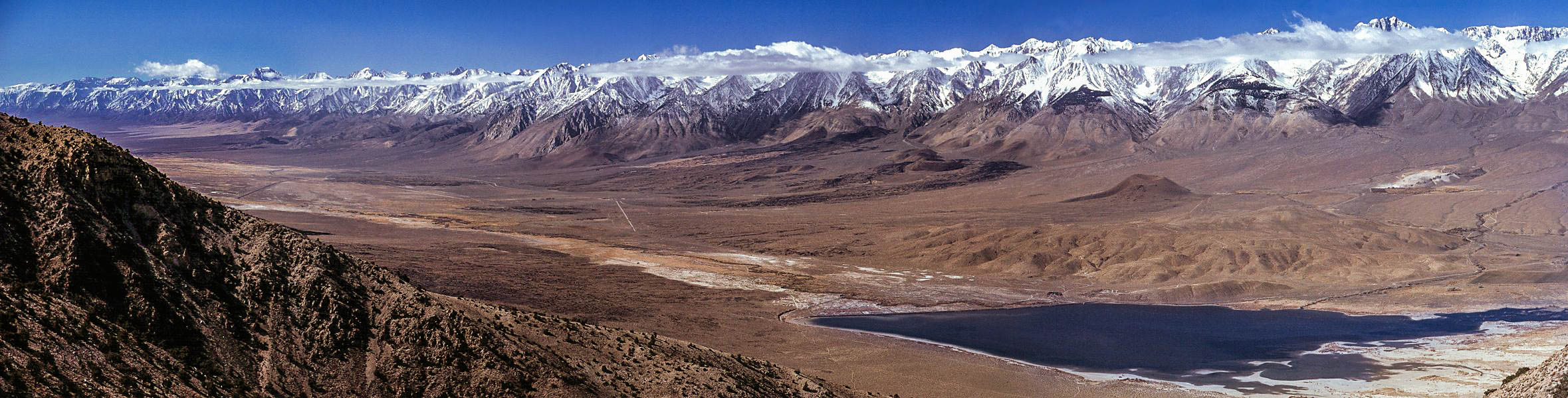
It helps to know the importance of Owens Valley when you travel to it. What was rich farmland in the beginning of the 20th century became the main water source for the city of Los Angeles a couple of decades later. The thirsty city to the south drained much of the water that was here, turning much of it into desert. The Owens River ran dry which turned Owens Lake at the south end of the valley into an alkali flat.
Through much litigation and struggle, the city is slowing returning some of the water but it will never be the same in our lifetime. Even so, this is one of the most ruggedly beautiful and historic areas in the state. The geography runs from the highest point in the lower 48 to the lowest point in the entire country.
Coming up from the desert below on highway 395, you pass up some impressive lava formations at the Coso Mountains, on the east side of the highway past Pearsonville on up to Little Lake.
There is a beautiful little lake at the tiny town of Little Lake, marking your entrance into the southern end of the valley. We’ll be here for another 140 or so miles before we exit via the northern end.
I like to divide the valley into two parts…the southern half and the northern half. Today, we’ll tackle the southern end.
The next town of any size along the highway will be Lone Pine. This pretty little town sits between those two points of extreme, Mt. Whitney and Death Valley. Just to the west of town, amidst a collection of spires, sits the summit of Mt. Whitney, the highest point in the continental United States at 14,497 feet.

From the middle of town, you can drive up Whitney Portal Road quite a ways up the side of the mountain to the trailhead where hearty hikers can go the rest of the way. We like the large waterfall here where on warmer days you can have a nice picnic. In the winter, if you can get up here, the waterfall is a spectacular frozen column of ice.

On the way back to town, you’ll see some familiar looking rock formations to the north of the road. These are the Alabama Hills and the recreation area is great to roam around, scramble on the rocks, and even have a picnic. Many, many movies, TV shows, and commercials have been filmed here which is why they look so familiar. You can download a map from the Lone Pine Chamber of Commerce to see where some of the more famous movie locations are.
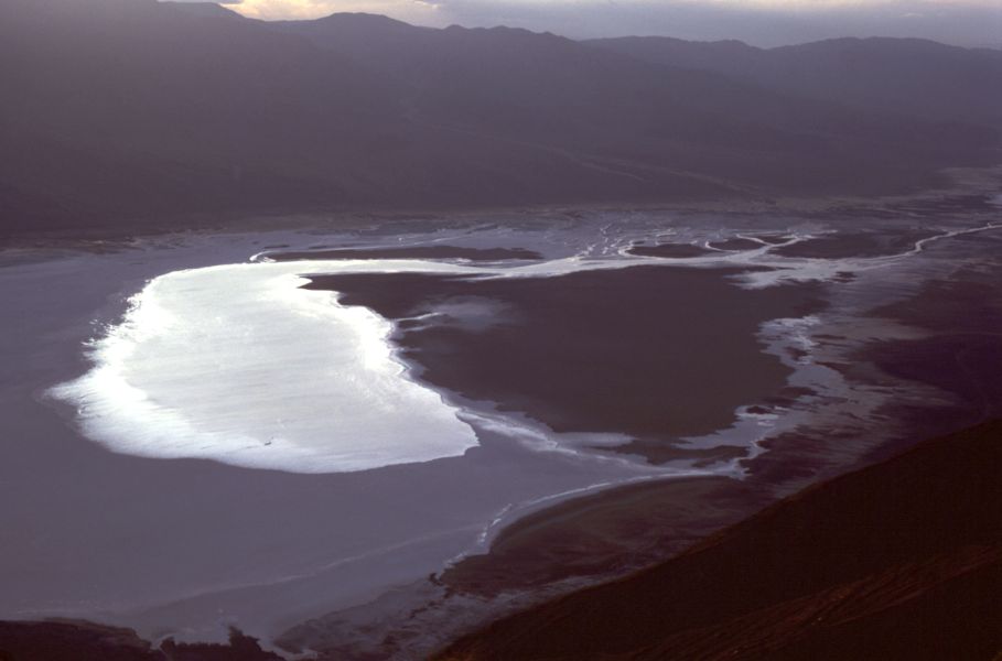
It’s about 85 miles southwest from the nearly 15,000 foot peak of Mt. Whitney to the Badwater in Death Valley. At 282 feet below sea level, it’s the lowest point in the United States. You can go back to Owens Lake and take highway 190 over to this spectacular national park but, for us, that’s a trip for another day.
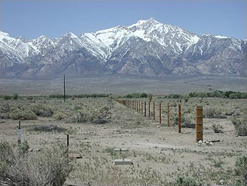
After a slice of pizza and a sandwich at the Pizza Factory in town, it’s back on the road. Just north of Lone Pine on the east side of the road you’ll see a small hill with a wooden fence, a monument, and a historical marker (no. 507) sign.
Sixteen bodies lay under the dirt here in a mass grave, the result of a massive earthquake in 1872. About 80 structures stood in town, mostly made of adobe which crumbled readily during the shaking. Only 20 structures were left standing and 27 people were left dead. Those that weren’t buried in their own services were interred here.
Seven miles north of town lies another melancholy site. Manzanar National Historic Site covers the area that was the Manzanar Relocation Center. During World War II, 10,000 people of Japanese descent were rounded up and put here for the duration of the war.

Manzanar in 1942
The camp was closed and mostly dismantled in 1945. For years, it was left alone out here in the bottom of the valley. We’d stop in and have the 550 acres to ourselves to explore. In 1985, forty years after it was shut down, it was declared a National Historic Site.
Manzanar today
Today, you can still explore the grounds, see the foundations of the barracks, see the couple of remaining structures like the gymnasium and the guardhouse, and visit the accessible interpretive center.

Continuing north, we come into the county seat of Inyo County, the town of Independence. Be sure to make a stop to see the old courthouse in the center of town. It was here, a group of vagrants were brought for hearings after being arrested in a remote area of Death Valley. One of them was named Charles Manson, who would eventually be taken to Los Angeles for the murder trial he is infamous for.
On the drive north, it takes little reminding to enjoy the view. The mountain ranges on either side…the steep, abrupt eastern escarpment of the Sierras and the gentler slopes of the White Mountains on the right…both rise over 14,000 feet. In the winter the view doesn’t get any better.
Passing out of Independence, we continue on this classic and legendary highway heading toward the northern half of the stark, barren, and exceptionally stunning Owens Valley.
-Darryl
Copyright 2012 – Darryl Musick
All Rights Reserved
Hwy 395 is a beautiful drive -- haven't been on that route in a long time. So much history along it, too. Would definitely like to see Manzanar National Historic Site sometime. Nice pics, excluding Manson.
ReplyDeleteManzanar's a moving place. For awhile, it seemed that it would be reclaimed by the land but fortunately it was saved for the historical nature of the place. There are a lot of places up here, like the earthquake victims grave, where you are at the epicenter of some major history, and yet you have the place to yourself. Too many to include all in the ariticles we're doing, but if you ever find yourself here, I recommend just taking a day and exploring every historical marker you can find.
ReplyDelete-Darryl
I've lived in California for 10 years and know pretty much nothing about this area. I need to explore Hwy 395 sometime. I know it's popular during Fall but I haven't had the chance to explore it yet.
ReplyDelete